Posts

MJO - WEATHER ENHANCER AND SUPPRESSOR
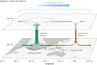
Image
MJO - WEATHER ENHANCER AND SUPPRESSOR MJO also known as Madden- Julian Oscillation is one of the most common weather-terms hovering among weather bloggers in their posts in social media. One might need to know what is MJO all about because most of the forecasts during monsoon time are centred around with this term.  In this article, we will explore MJO and its different phases and how it influences North- East monsoon. So, let's dive in to the topic...  MJO also known as Madden- Julian Oscillation can be defined as an eastward moving pulse of convection , winds and pressure near the equator ( like a train whose destination is towards east)  which typically occurs every 30-60 days and comes back to its initial starting point ( after reaching the destination, train travels back thus travelling all over the globe) . It is a traversing weather phenemenon which is mostly   notable in Indian and Pacific oceans.  The Julian Oscillation is the energy supplier for tropical cyclones near the

2017 NORTH INDIAN OCEAN CYCLONE SEASON AND CYCLONE OCKHI

Image
  2017 NORTH INDIAN OCEAN CYCLONE SEASON AND CYCLONE OCKHI 1. CYCLONE MAARUTHAA:[TROPICAL STORM] On April 13, an area of low pressure formed in the South Bay of Bengal, under the influence of a persistent area of convection, in a span of six hours.  Under favorable conditions, rapid deepening took place, and the system was classified as a depression on April 15. The system moved very fast under the influence of mid-latitude trough in westerlies lying over India in the middle and upper tropospheric levels. [5]  However, strong vertical wind shear and unfavourable MJO inhibited rapid intensification or further intensification of the system. Moving northeastwards, it reached its peak intensity in the early hours of 16th.  DURATION: April 15- April 17 It was at its peak intensity of 75km/h and intensity of about 996mb[hpa]pressure. It formed in Southern Bay of Bengal and moved in NNE direction and headed towards Andaman and Nicobar,    Climatologically, the formation of tropical cyclones i

2016 North Indian cyclone season and special Vardah post.

Image
  2016 NORTH INDIAN CYCLONE SEASON AND CYCLONE VARDAH   It was the deadliest season since  2010 , killing more than 400 people. The season was an average one, seeing four named storms, with one further intensifying into a very severe cyclonic storm. The first named storm,  Roanu , developed on 19 May while the season's last named storm,  Vardah , dissipated on 18 December.  1. CYCLONE ROANU [TROPICAL STORM] DURATION: 17 May - 22 May It was at its peak intensity of about 85km/h, 983hpa[mbar] lowest pressure. Under the influence of a  trough , a  low pressure area  formed over the Bay of Bengal.  It slowly consolidated, prompting the IMD to classify it as a depression. It took straight northward track and later took NNE direction. LANDFALL: NW of Chittagong, Bangladesh. It's outer bands made heavy rains to Kolkata. 2. DEPRESSION ARB 01 [TROPICAL STORM] DURATION: 27 Jun - 29 Jun It was at its peak intensity of about 45km/h, 996hpa[mbar] lowest pressure. it took westward track and

2015 North Indian cyclone season

Image
2015 NORTH INDIAN OCEAN CYCLONE SEASON and NORTHEAST MONSOON IN KTCC REGION. 1. CYCLONIC STORM ASHOBAA [TROPICAL STORM] DURATION: Jun 7- Jun 12 It was at its peak intensity of about 85km/h, 990hpa[mbar] pressure. Since, it dragge all the moisture and convection pulse SWM was stalled. FORMATION: South ARB It took north track later moved in NNW direction. LANDFALL: East Oman Waterlogging was experienced in parts of UAE, Kalba. RAINFALL RECORDED {24 HRS} Masirah Island, Oman- 225mm 2. DEPRESSION BOB 01 [MONSOON] DURATION: Jun 20- Jun 21 It was at its peak intensity of about 45km/h, 994hpa[mbar] pressure. FORMATION: SE of Vishakhapatinam coasts It took an general NW track. LANDFALL: Gopalpur-Puri, Odisha RAINFALL RECORDED Malkangiri, Odisha- 320mm 3. DEEP DEPRESSION ARB 02 [MONSOON] DURATION: Jun 22- Jun 24 It was at its peak intensity of about 55km/h, 988hpa[mbar] pressure. FORMATION: Offshore of Gujarat coasts. RAINFALL RECORDED [in mm] Gujarat ---------- Bagasara- 636 Dhari- 511 Varujav

Rainfall recorded in Tamilnadu ending at 24.08.20 8.30am (in mm)

 RAINFALL RECORDED IN TAMILNADU ENDING AT 24.08.20 8.30am (in mm:) Trichy ----------- Pullambadi- 120.8 Kallakudi- 110.2 GOLDEN ROCK- 60 Devimangalam- 60 Lalgudi- 57 Samayapuram- 56 Vathalai Anaikattu- 51 Thenparanadu- 47 Marunkapuri- 45.2 Kovilpatti- 45.2 Thuraiyur- 45 Trichy Junction- 40 Navalur Kuttapattu- 40 Nandhiyar Central- 36.6 Trichy town- 34 Trichy AP- 32.3 Koppampatte- 32 Sirukudi- 22 Manapparai- 14.2 Ponniyar dam- 10 Perambalur ------------------- Veppanthatai- 110 Perambalur- 97 Chettikulam- 44 Thalluthalai- 27 Krishnapuram- 23 Padalur- 17 V.  Kalathur- 2 Vellore ------------- VCS MILL Ammudi- 100 Ponnai dam- 76.4 Melalathur- 46.8 Katpadi- 43.4 Kudiyatham- 30 Virinjipuram AWS- 22 Tiruvallur ----------------- Thiruthani- 100 RK Pet- 72 Pallipattu- 56 Thiruthani AWS- 50 Poondi- 2 Tiruvallur- 1 Cuddalore ----------------- Bhuvanagiri- 91 Sethianthope- 50 Kothavancheri- 30 Srimushnam- 21.2 Vadakuthu- 21 Pozhanthurai- 18.3 Kurinjipadi- 15.3 Panruti- 6 Parangipettai- 4 Dharmapur

2014 North indian Ocean cyclone season

Image
2014 NORTH INDIAN OCEAN CYCLONE SEASON was a bit subdued or below norml cyclone season with only 3 cyclones formed in the basin, also 2 formed in Arabian Sea itself making Bay of Bengal to host only one cyclone. 1. DEPRESSION [TROPICAL STORM] DURATION: Jan 4- Jan 7 It was at its peak with about 45km/h winds, 1004hpa[mbar] pressure. FORMATION: Near Srilanka coasts. It affected North Srilanka coasts mostly with heavy rains and gusty winds. RAINFALL RECORDED Vavuniya, Srilanka- 210mm [24 hrs] Puttalam, Srilanka- 50mm Trincomalee, Srilanka- 50mm 2. DEPRESSION BOB 02 DURATION: May 21- May 23 Peak intensity was about 45km/h, 1000hpa[mbar] pressure. FORMATION: North BOB DIRECTION: NNE It made landfall in Odisha. RAINFALL RECORDED [24 hrs] Bhawanipatna, Odisha- 208mm Baleshwar, Odisha- 210mm 3. CYCLONIC STORM NANAUK [TROPICAL STORM] DURATION: Jun 10- Jun 14 It was at its peak intensity of 85km/h, 986hpa[mbar] pressure. FORMATION: West ARB DIRECTION: NE, NNW, N It weakened gradually due to high

2013 North Indian Ocean Cyclone Season

Image
2013 NORTH INDIAN OCEAN CYCLONE SEASON was an active cyclone season with 5 cyclonic storms, 5 depressions and many more. 1. CYCLONIC STORM VIYARU [TROPICAL STORM] DURATION: May 10- May 17 It was at its peak intensity of 85km/h winds, 990hpa[mbar] pressure. FORMATION: Southern BOB It started to move in W-NW direction, however due to subtropical ridge it turned ENE direction. LANDFALL: Chittagong, Bangladesh. 2. DEPRESSION BOB 02 [MONSOON] DURATION: May 29- May 31 It was at its peak intensity of 45km/h sustained winds, 990hpa[mbar] pressure. FORMATION: North BOB DIRECTION: North LANDFALL: West Bengal. It affected parts of Bihar and Jharkhand with heavy rains. RAINFALL RECORDED [May 30] Contai, West Bengal- 260mm [24 hrs] 3. DEPRESSION BOB 03 [MONSOON] DURATION: Jul 30- Aug 1 It was at its peak intensity of 45km/h sustained winds, 990hpa[mbar] pressure. FORMATION: North BOB DIRECTION: West. It made landfall in Balasore, Odisha - Ditgha, West Bengal. It also affected Madhya Pradesh with he