2017 NORTH INDIAN OCEAN CYCLONE SEASON AND CYCLONE OCKHI
2017 NORTH INDIAN OCEAN CYCLONE SEASON AND CYCLONE OCKHI
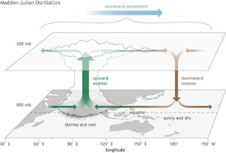
1. CYCLONE MAARUTHAA:[TROPICAL STORM]On April 13, an area of low pressure formed in the South Bay of Bengal, under the influence of a persistent area of convection, in a span of six hours. Under favorable conditions, rapid deepening took place, and the system was classified as a depression on April 15.The system moved very fast under the influence of mid-latitude trough in westerlies lying over India in the middle and upper tropospheric levels.[5] However, strong vertical wind shear and unfavourable MJO inhibited rapid intensification or further intensification of the system. Moving northeastwards, it reached its peak intensity in the early hours of 16th.
DURATION: April 15- April 17
It was at its peak intensity of 75km/h and intensity of about 996mb[hpa]pressure.
It formed in Southern Bay of Bengal and moved in NNE direction and headed towards Andaman and Nicobar, Climatologically, the formation of tropical cyclones in the Bay of Bengal at this time of the year is rare. Only twelve Cyclonic Storms have developed over the Bay of Bengal this early in the year between 1891 and 2016 made landfall in Myanmar.
2. VERY SEVERE CYCLONE MORA[ CAT- 1]
The system moved fast under the influence of mid-latitude trough in westerlies lying over India in the middle and upper tropospheric levels and the anti-cyclonic cyclonic circulation lying to the northeast of the system.
DURATION: 28 May- 31 May
It was at its peak intensity of about 110km/h, intensity about 975hpa[mbar] pressure.
It formed in South-East Bay of Bengal and initially moved NE and later north direction and made landfall in Southern Bangladesh. It affected as a pre-low in Andaman islands.
3. DEEP DEPRESSION BOB 03:[MONSOON]
DURATION: 11 June- 13 June
It was at its peak intensity of about 55km/h, intensity about 988hpa[mbar] pressure. An anti-cyclonic circulation lay to the southeast of the system centre leading to poleward outflow favouring genesis of the system.
It formed in Northern edge of Bay of Bengal and moved NNE direction and made its way towards Bangladesh coasts. Rangamati, Chittagong districts were the most affected in Bangladesh. Torrential rainfall destructed Northeast India, with Cherrapunji recording 320mm in fraction of hours.
4. DEPRESSION BOB 04:[MONSOON]
DURATION: July 18- July 19
It was at its peak intensity of about 45km/h, with high intensity being 992hpa[mbar] pressure. in 24 hours, along with sustained winds of 45 km/h (30 mph) affected the region,causing at least a dozen villages to be submerged in floodwater and five bridges to be washed away.
It formed in West-Central Bay of Bengal and headed in NW direction and gave plenty of rainfall in Odisha coasts.
RAINFALL RECORDED[in mm;]
Dondilohara, Chattisgarh- 270
Dabubagan, Odisha- 200
5. DEPRESSION BOB 05 [TRANSISTION]
DURATION: Oct 19- Oct 22'
It was at its peak intensity of about 45km/h, with 997hpa[mbar] pressure. Area of thunderstorm activity located in the eastern Bay of Bengal as having a partially exposed low level center while located in a marginally favorable environment for further development. Odisha state government declared the heavy rains caused by the storm as a "State-Specific Disaster". Despite being initially forecasted to intensify further, the depression tracked into an environment with strong wind shear and failed to intensify.
It formed in East Bay of Bengal and headed initially north later curved to NE direction providing rains in NE and East India and made landfall in Odisha coasts.
Rainfall [in mm:]
Cherrapunji- 283
Bankura- 279
Gopalganj- 279
Puri- 274
Halishar- 116
Kolkata- 110
6. DEPRESSION BOB 06
DURATION: November 15- November 17
It was at its peak intensity of about 45km/h, with only 1000hpa[mbar] pressure. It formed off Srilanka coasts, i.e SW Bay of Bengal and moved northern direction and later changing to NE, leading to heavy to extremely heavy rains in Tamilnadu, Andhra Pradesh, Odisha, West Bengal coasts[ East coast rider]
Rainfall recorded:
Mylapore, Chennai- 320mm[less than 6 hours]
Digha, West Bengal- 60mm
Halisahar- 58mm
Kolkata- 53mm
Parganas- 50mm
7.


Comments
Post a Comment